Geography is not just about memorizing capitals or identifying countries on a map. It’s about understanding our world – its physical features, its cultures, its interconnectedness. The Montessori method, renowned for its hands-on, sensory-based learning, offers a unique approach to geography that fosters a deep understanding of the world in which we live.
Key Takeaways
- Montessori geography emphasizes understanding the world’s physical and cultural aspects, beyond just map reading.
- Tactile learning tools like sandpaper globes and puzzle maps are central to the Montessori approach.
- The curriculum includes exploring global cultures to foster empathy and global awareness.
- Geography lessons are age-appropriate, evolving from basic exploration to in-depth studies.
- Hands-on activities and experiments deepen children’s understanding of the world’s geography.
What is the Montessori Philosophy on Geography
The Montessori geography curriculum, through its structured progression, guarantees that children cultivate a comprehensive understanding of the world, equipping them to become enlightened and empathetic global citizens.
Central to Montessori education is the conviction of the interconnectedness of all entities. This ethos is deeply embedded in its approach to geography. Here, children are guided to perceive the world as a cohesive network of both physical landscapes and cultural intricacies. Rather than just committing facts to memory, Montessori learners are inspired to delve into, inquire about, and truly comprehend the world that surrounds them.
Physical Geography in Montessori
Physical geography in the Montessori curriculum is about more than just identifying continents or countries on a map. It’s about understanding the physical features of our planet and how they relate to one another.
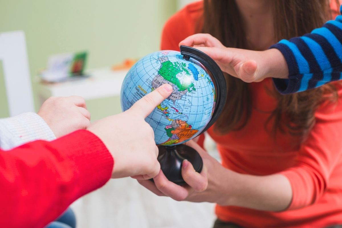
Globes
The Montessori classroom is incomplete without its signature globes. These geography materials are instrumental in laying the foundation for geographical understanding.
- Sandpaper Globe: This is the child’s first introduction to the vast world. The globe has two distinct textures: rough for land and smooth for water. By feeling these textures, children can easily differentiate between continents and oceans, making it a tactile learning experience.
- Colored Globe: As the name suggests, this globe is all about colors. Each continent is painted in a specific Montessori-approved color. This color-coding system aids in easy recognition, helping children memorize and identify continents quickly.
| Continent/Country | Montessori Color |
|---|---|
| North America | Orange |
| South America | Pink |
| Europe | Red |
| Asia | Yellow |
| Africa | Green |
| Australia/Oceania | Brown |
| Antarctica | White |
| USA (within N. America) | Purple |
Puzzle Maps
These are detailed wooden maps with pieces representing individual regions or countries. Like the Montessori globe, they are color-coded for easy recognition. As children become more familiar with the globe, they transition to puzzle maps to delve deeper into individual continents, countries, and even states or provinces.
- Continent Maps: Before diving into specific countries, children are introduced to each continent as a whole. These large wooden maps have pieces for each continent, color-coded to match the colored globe. It’s a step up from the globe, giving children a flat, detailed view of each continent.
- Country Maps: As children progress, they start exploring individual countries within each continent. These maps are detailed, with pieces for each country, again color-coded for easy recognition. Some maps even have pieces for major rivers and mountain ranges, adding another layer to the learning experience.
- Pin Maps: Taking the puzzle map concept a step further, pin maps come into play. These maps are flat, with holes representing cities or other significant geographical features. Children use pins to mark these spots, enhancing their fine motor skills while learning about geography. It’s a hands-on way to learn about specific geographical features and their locations.
Cultural Geography in Montessori
While physical geography deals with the tangible aspects of our planet, cultural geography delves into the intangible – the cultures, traditions, and histories that shape our world. Cultural geography in Montessori is a journey through the rich tapestry of human civilization, celebrating the diversity and interconnectedness of societies worldwide.
- Study of Human Society and Culture: Montessori education believes in nurturing global citizens. Children embark on a virtual world tour, exploring various cultures. They learn about traditional dances of Africa, the festivals of Asia, the art of Europe, and more. This immersive approach ensures that students not only know about different cultures but appreciate and respect them.
- Flags of the World: Flags are more than just pieces of fabric; they tell stories of nations. In Montessori classrooms, children get hands-on experience with flags from around the world. They learn the significance of colors, symbols, and patterns, understanding the history and values each flag represents.
- Cultural Artifacts and Stories: Beyond flags, Montessori classrooms often feature artifacts, books, and stories from different cultures. A Japanese tea set, an African drum, or an Australian didgeridoo might find its place in the classroom, each with a story to tell, enriching the cultural learning experience.
Montessori Geography Scope and Sequence
The beauty of the Montessori geography curriculum lies in its progressive nature. It’s akin to building a structure, brick by brick, ensuring a solid foundation before adding more layers.
Children begin their journey with tangible, hands-on materials that bring abstract concepts to life. The sandpaper globes, for instance, offer a tactile experience, allowing children to feel the roughness of land and the smoothness of water. As they progress, they transition to more detailed materials. Maps, both political and physical, introduce them to countries, capitals, major landmarks, and geographical features. Flags from different nations give them a glimpse into the rich tapestry of global cultures.
Cultural studies seamlessly integrate with geography, offering students insights into the customs, traditions, and lifestyles of people from various parts of the world. This systematic approach ensures continuity in learning, allowing students to connect the dots, layer by layer, and gain a holistic understanding of global geography.
Montessori Geography Across Different Age Groups
The Montessori geography curriculum is tailored to cater to different age groups, ensuring age-appropriate learning.
Ages 0-3: Discovering the Immediate World
At this tender age, children are just beginning to find their footing in the world. Their understanding is primarily centered around their immediate environment. Activities focus on:
- Recognizing family members and familiar faces.
- Exploring their home environment through touch, taste, and smell.
- Simple songs and stories that introduce concepts of “near” and “far.”
Ages 3-6: Sensory Exploration and Basic Geography
This phase is characterized by a heightened sense of curiosity. Children are eager to touch, feel, and understand their surroundings.
- Introduction to the sandpaper globe, where they can feel the difference between land and water.
- Puzzle maps become a favorite, helping them identify continents and major countries.
- Stories and songs about different cultures, introducing them to the diverse world beyond their immediate surroundings.
Ages 6-9: Delving into History and Advanced Geography
As children grow, their capacity to understand complex concepts increases. The Great Lessons play a pivotal role during this phase.
- Introduction to the history of the world, from the formation of the earth to the evolution of life.
- Detailed study of physical properties, such as mountains, rivers, and deserts.
- Exploration of human society, understanding traditions, festivals, and lifestyles of people from different parts of the world.
Ages 9-12: Comprehensive Study and Global Awareness
This stage sees children becoming young scholars, eager to understand the intricacies of the world.
- Economic geography becomes a focal point, where they learn about trade, resources, and the interdependence of nations.
- Detailed projects on various countries, exploring their history, culture, and contribution to the global ecosystem.
- Discussions on current events, helping them connect classroom learning with real-world happenings.
Montessori Geography Activities & Experiments
Montessori education thrives on active engagement, and geography is no exception. Beyond maps and materials, children are encouraged to delve into a series of activities and experiments that bring geographical and environmental concepts to life. These hands-on experiences foster a deeper understanding and appreciation of the world around them.
The Role of the Sun and Earth
- Day and Night Cycle Activity: Using a globe and a flashlight, children can simulate the rotation of the Earth and observe the alternating patterns of day and night. This visual demonstration helps them grasp the concept of Earth’s rotation and its impact on daily life.
- Seasons and Tilt Experiment: With the aid of models, children can understand how the Earth’s tilt on its axis, combined with its orbit around the sun, results in different seasons. This activity can be enhanced with discussions about how various cultures celebrate seasonal changes.
- Time Zone Demonstrations: Using world clocks or interactive apps, children can explore the concept of time zones, understanding why different parts of the world experience day and night at different times.
The Work of Wind
- Temperature and Air Movement: Simple experiments using balloons or bags can demonstrate how air expands when heated and contracts when cooled. This activity provides insights into wind formation and the basics of meteorology.
- Wind-Powered Races: Using simple materials like straws and paper boats, children can engage in races powered by their breath, understanding the force and direction of wind.
- Ocean Currents and Wind: With the help of water basins and colored dyes, children can observe how wind influences the movement of water, leading to the formation of ocean currents.
The Work of Water
- Water Cycle in a Bag: By sealing water in a clear plastic bag and placing it in sunlight, children can observe the processes of evaporation, condensation, and precipitation firsthand, gaining a clear understanding of the water cycle.
- Erosion and Landscape Activity: Using sand, soil, and water, children can simulate rain and observe its effects on different terrains. This experiment highlights the power of water in shaping landscapes and the importance of vegetation in preventing erosion.
- Floating and Sinking Experiment: To understand the concept of buoyancy and the properties of water, children can experiment with different objects, predicting and observing which ones float and which ones sink.
Land and Water Forms Activity
- Landform Models: Using clay or playdough, children can create models of various landforms such as islands, peninsulas, mountains, valleys, and plateaus. This tactile activity helps them understand the physical features of the Earth’s surface.
- Water Form Trays: Trays with molded land and water forms, filled with water, allow children to visually and tangibly differentiate between lakes, islands, bays, peninsulas, and more.
Cultural Exploration
- Continent Boxes: Each box is filled with artifacts, pictures, and items from a specific continent. Children can explore these boxes to gain insights into the cultures, animals, and landmarks of different regions.
- Flag Matching: Children can match flags to their respective countries, learning about national symbols and colors.
Animal Habitats
- Habitat Sorting: Using cards or miniature animal figures, children can sort animals based on their habitats, such as desert, polar regions, rainforests, and oceans.
- Animal Migration Patterns: Through interactive maps, children can trace the migration patterns of various animals, understanding the reasons behind these seasonal movements.
Exploring Natural Resources
- Resource Mapping: Children can place markers or stickers on world maps to indicate where certain natural resources are found, such as oil in the Middle East or gold in South Africa.
- Hands-on Resource Kits: Kits containing samples of resources like coal, cotton, or spices can be explored, helping children understand the tangible goods that come from different regions.
Weather and Climate Studies
- Weather Charting: Children can maintain a daily weather chart, noting down observations about temperature, cloud cover, and precipitation. Over time, this can lead to discussions about climate patterns.
- Climate Zones Exploration: Using layered maps, children can explore different climate zones of the world, understanding the variations in weather and temperature.
| Age Group | Activity | Description |
|---|---|---|
| Ages 0-3 | Recognizing Familiar Faces | Introducing children to family members and other familiar faces. |
| Sensory Exploration of Home | Encouraging children to touch, taste, and smell items in their immediate environment. | |
| Simple Songs and Stories | Using songs and stories to introduce concepts of “near” and “far.” | |
| Ages 3-6 | Day and Night Cycle Activity | Using a globe and flashlight to simulate Earth’s rotation and observe day-night patterns. |
| Seasons and Tilt Experiment | Using models to understand Earth’s tilt, its orbit, and the resulting seasons. | |
| Landform Models | Using clay or playdough to create models of various landforms. | |
| Water Form Trays | Trays with molded land and water forms for tactile differentiation. | |
| Ages 6-9 | Time Zone Demonstrations | Using world clocks or apps to explore the concept of time zones. |
| Temperature and Air Movement | Experiments with balloons or bags to understand wind formation. | |
| Wind-Powered Races | Races using straws and paper boats to understand the force of wind. | |
| Water Cycle in a Bag | Observing evaporation, condensation, and precipitation processes. | |
| Erosion and Landscape Activity | Simulating rain to observe its effects on terrains. | |
| Floating and Sinking Experiment | Experiments to understand buoyancy and water properties. | |
| Cultural Exploration | Exploring continent boxes filled with artifacts and items. | |
| Flag Matching | Matching flags to countries to learn about national symbols. | |
| Ages 9-12 | Ocean Currents and Wind | Observing how wind influences water movement and ocean currents. |
| Animal Habitats | Sorting animals based on habitats and tracing migration patterns. | |
| Exploring Natural Resources | Mapping natural resources and exploring hands-on resource kits. | |
| Weather and Climate Studies | Maintaining a daily weather chart and exploring climate zones. |